Mapbox Blog
Stay informed with insightful content on how Mapbox solutions are revolutionizing industries.

Maps
Featured Blog
From airports to stadiums, maps are elevating the soccer fan experience
From airport wayfinding to stadium maps and local tourism guides, apps are upping their location game.
Thank you! Your submission has been received!
Oops! Something went wrong while submitting the form.

Releases
Mapbox GL JS v2.2.0: GeoJSON performance improvements and level roofs on 3D terrain
Mapbox GL JS v2.2.0: GeoJSON performance improvements and level roofs on 3D terrain
Releases
GL JS
3D
Maps

Mapping for community rights in the Congo Basin
Mapping for community rights in the Congo Basin
Community
Conservation
Data
Business Intelligence
Climate

Maps
30+ meter imagery update: improved recency, color, and resolution for seamless 3D terrain
30+ meter imagery update: improved recency, color, and resolution for seamless 3D terrain
Maps
No items found.
Maps
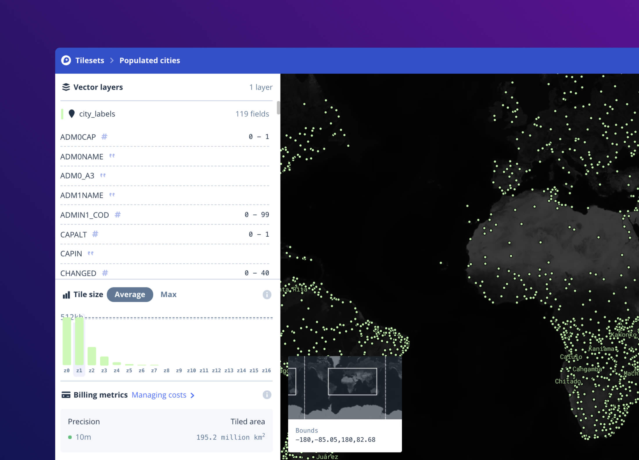
Tileset explorer: tile size metrics, x-ray data preview, job and recipe history for MTS
Tileset explorer: tile size metrics, x-ray data preview, job and recipe history for MTS
Maps
API
Cartography
Data
Developer Tools
Developers

NCX: Precision carbon forestry for all landowners
NCX: Precision carbon forestry for all landowners
Conservation
Environment
Community
Data
Storytelling

Maps
Real estate intelligence with the MTS (Mapbox Tiling Service)
Real estate intelligence with the MTS (Mapbox Tiling Service)
Maps
Built With Mapbox
Maps
MTS

Releases
On-device routing + flexible and versatile camera + 40% faster rendering performance: Mapbox Navigation SDK v2
On-device routing + flexible and versatile camera + 40% faster rendering performance: Mapbox Navigation SDK v2
Releases
Navigation
Android
iOS

VaccineFinder: Scaling for a pandemic
VaccineFinder: Scaling for a pandemic
Community
Public Health
Data Visualization

explorer.land: Regrowing confidence in forest restoration projects with maps and data
explorer.land: Regrowing confidence in forest restoration projects with maps and data
Environment
Conservation
Agriculture
Built With Mapbox

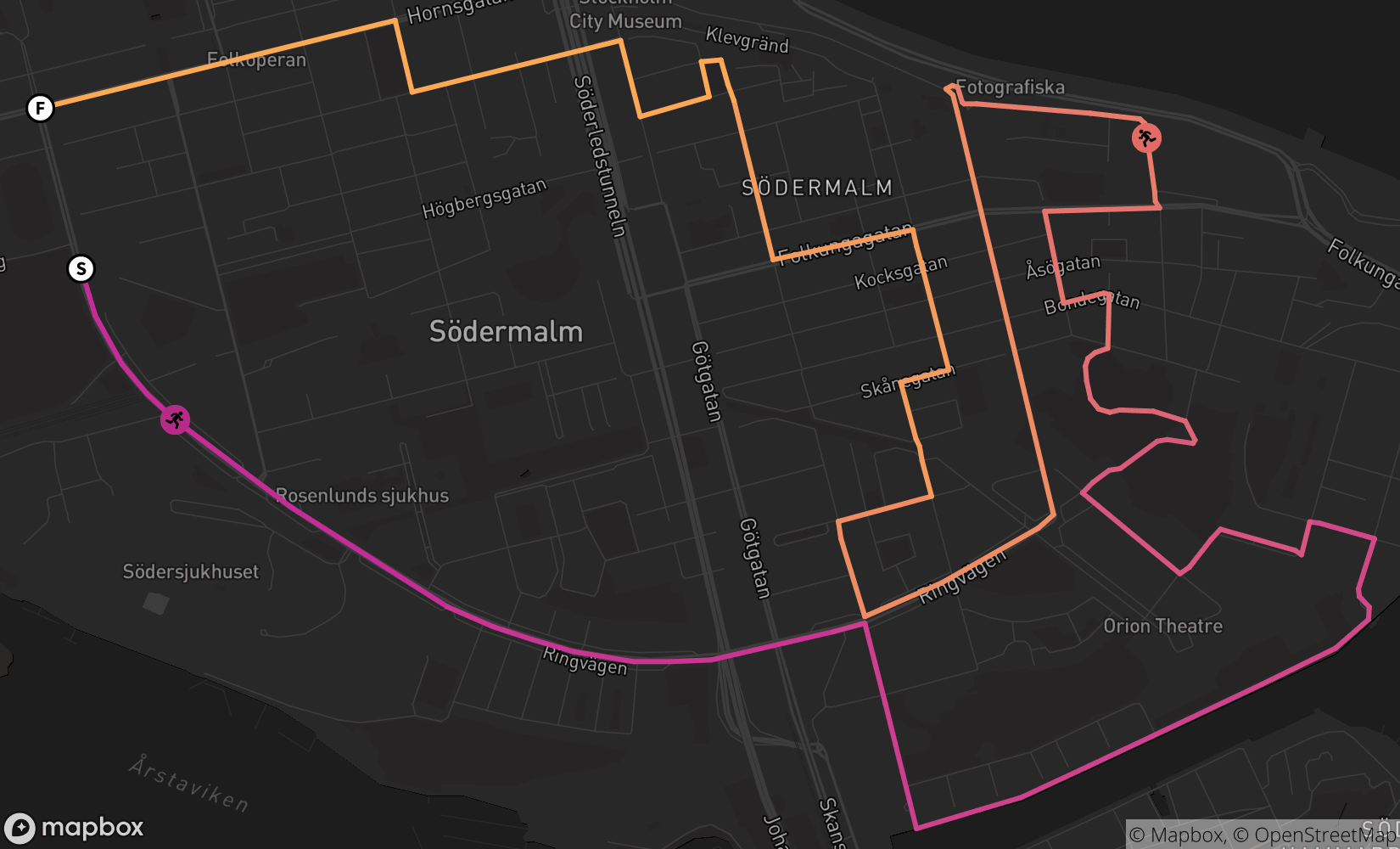
Running the Stairs of LA
Running the Stairs of LA
Storytelling
Built With Mapbox
How to utilize Mapbox Movement data for mobility insights
How to utilize Mapbox Movement data for mobility insights
Data
Movement Data

Company
Peter Sirota, CEO of Mapbox
Peter Sirota, CEO of Mapbox
Company
No items found.

Data
Build a ski trail map using OpenStreetMap and MTS
Build a ski trail map using OpenStreetMap and MTS
Data
MTS
Data
Open Data
Maps
Outdoor
Maps
Padding & Bounding Box in the Static Images API
Padding & Bounding Box in the Static Images API
Maps
API
Map Design

Releases
Efficient pitched tile loading, Precise CJK labels, and JS Promises: Mapbox GL JS v2.1.1
Efficient pitched tile loading, Precise CJK labels, and JS Promises: Mapbox GL JS v2.1.1
Releases
GL JS
3D
Developers
%2520(1).png)
Releases
Sky API: Atmospheric Scattering Algorithm for 3D Maps
Sky API: Atmospheric Scattering Algorithm for 3D Maps
Releases
No items found.

Wrap labels around mountains with 3D Terrain in Studio
Wrap labels around mountains with 3D Terrain in Studio
Built With Mapbox
Cartography
Maps
Studio
3D

Releases
3D Maps, iOS Metal, Kotlin & Swift APIs in Mobile Maps SDK v10 Beta (Android + iOS)
3D Maps, iOS Metal, Kotlin & Swift APIs in Mobile Maps SDK v10 Beta (Android + iOS)
Releases
Mobile
Android
iOS

Data Visualization Components with full 3D integration in Mapbox Studio
Data Visualization Components with full 3D integration in Mapbox Studio
Data Visualization
3D
Mapbox Studio

3D Design: Terrain and Sky Component in Mapbox Studio
3D Design: Terrain and Sky Component in Mapbox Studio
Mapbox Studio
Map Design
3D

Maps
Updated Aerial Imagery in the US
Updated Aerial Imagery in the US
Maps
Agriculture
Built With Mapbox
Data
Imagery

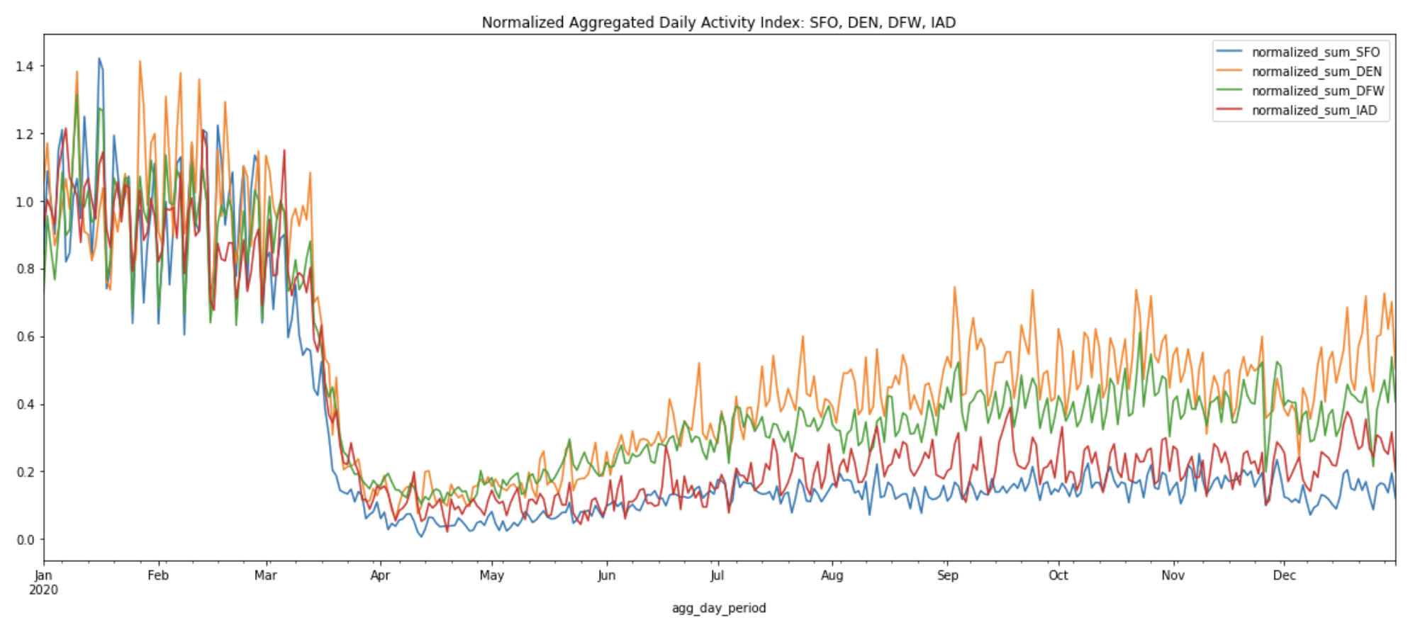
Inauguration vs Pandemic: What Can Shut Down Washington, D.C.?
Inauguration vs Pandemic: What Can Shut Down Washington, D.C.?
Movement Data
Data

Data
Retail Recovery Using Movement Data
Retail Recovery Using Movement Data
Data
Data
Business Intelligence
Movement Data
.png)
Company
VP of People @Mapbox - Melissa Nixon
VP of People @Mapbox - Melissa Nixon
Company
No items found.
There are no items matching the current filters.
Ready to get started?
Create an account or talk to one of our experts.