Mapbox Blog
Stay informed with insightful content on how Mapbox solutions are revolutionizing industries.

Maps
Featured Blog
From airports to stadiums, maps are elevating the soccer fan experience
From airport wayfinding to stadium maps and local tourism guides, apps are upping their location game.
Thank you! Your submission has been received!
Oops! Something went wrong while submitting the form.

Maps
Hochauflösende Luftaufnahmen für Deutschland und Österreich
Hochauflösende Luftaufnahmen für Deutschland und Österreich
Maps
Imagery
Satellite Imagery

Maps
Nouvelles images aériennes pour la France et le Portugal
Nouvelles images aériennes pour la France et le Portugal
Maps
Imagery
Satellite Imagery
.png)
Data-driven health logistics in the Indo-Pacific
Data-driven health logistics in the Indo-Pacific
Community
Health
Public Health
Logistics
Business Intelligence
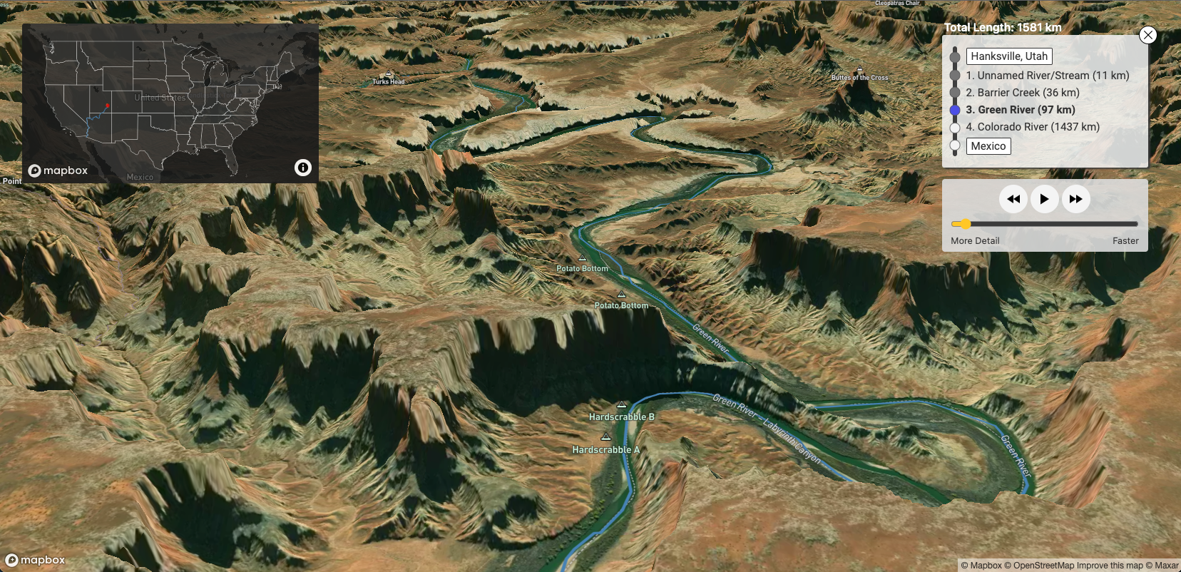
River Runner - How I Built It
River Runner - How I Built It
3D
Community
Environment
Education
GL JS

Maps
Optimizing App Startup with the Maps SDK
Optimizing App Startup with the Maps SDK
Maps
No items found.

Maps
Launching Maptober Mapping Challenge
Launching Maptober Mapping Challenge
Maps
MTS

Uncovering the distribution of ‘sundown towns’
Uncovering the distribution of ‘sundown towns’
Community
Social Justice
History
GL JS
Map Design
Data
New aerial imagery for Germany and Austria
New aerial imagery for Germany and Austria
Data
Imagery
Satellite Imagery

Releases
Taking your navigation to the next level
Taking your navigation to the next level
Releases
No items found.

CNN maps the most diverse USA ever
CNN maps the most diverse USA ever
Census
Open Data
Data Visualization
Social Justice
Community

Conservation tools for all: Map builders at the World Conservation Congress
Conservation tools for all: Map builders at the World Conservation Congress
Community
Environment
Conservation
Non-Profit and NGO
Humanitarian

Maps
Helium is the world’s fastest-growing wireless network ever
Helium is the world’s fastest-growing wireless network ever
Maps
API
Data Visualization
Imagery
Satellite Imagery
App Development
Maps
New aerial imagery for France and Portugal
New aerial imagery for France and Portugal
Maps
No items found.

Color blindness simulator in Studio
Color blindness simulator in Studio
Studio
Map Design
Cartography

Navigation
Precise and simple locations with Mapbox Dash and what3words for voice and text
Precise and simple locations with Mapbox Dash and what3words for voice and text
Navigation
Android
App Design
App Development
Automotive
Asset Tracking

Releases
New Release of Global Movement Data
New Release of Global Movement Data
Releases
Movement Data
Data

Explore WWII history in 3D with Project ‘44
Explore WWII history in 3D with Project ‘44
Maps
3D
History
Storytelling
Community

Maps
National Craft Beer Map
National Craft Beer Map
Maps
No items found.

Maps
Australia’s Bureau of Meteorology combines Mapbox and ESRI
Australia’s Bureau of Meteorology combines Mapbox and ESRI
Maps
GL JS
Studio
Weather
Data Visualization

Grade 7 students save wetland with a storytelling map
Grade 7 students save wetland with a storytelling map
Environment
Storytelling
Community
Education

Maps
Customizable Tile Size Limits
Customizable Tile Size Limits
Maps
No items found.

Releases
Electronic Horizon Launches
Electronic Horizon Launches
Releases
Automotive
Navigation

Quickly create custom marker and heatmap styles in Mapbox Studio
Quickly create custom marker and heatmap styles in Mapbox Studio
Cartography
Data Visualization
Map Design
Mapbox Studio
Studio

Search
Improved Search coverage for 44 European countries
Improved Search coverage for 44 European countries
Search
Search
App Development
Boundaries
Location Intelligence
Android
There are no items matching the current filters.
Ready to get started?
Create an account or talk to one of our experts.