Mapbox Blog
Stay informed with insightful content on how Mapbox solutions are revolutionizing industries.

Maps
Featured Blog
From airports to stadiums, maps are elevating the soccer fan experience
From airport wayfinding to stadium maps and local tourism guides, apps are upping their location game.
Thank you! Your submission has been received!
Oops! Something went wrong while submitting the form.

Fundraising Maps Convert Visitors to Donors
Fundraising Maps Convert Visitors to Donors
Community
Environment
Non-Profit and NGO
Conservation
Retail

Logistics
Optimize your fleet operations with Mapbox Fleet
Optimize your fleet operations with Mapbox Fleet
Logistics
Navigation
Solutions

Logistics
Reduce Fuel Cost by Optimizing your Delivery Service
Reduce Fuel Cost by Optimizing your Delivery Service
Logistics
Asset Tracking
Logistics
%2520(1).png)
Releases
Electric Vehicle Routing Available in Private Preview
Electric Vehicle Routing Available in Private Preview
Releases
Navigation
Electric vehicles
Automotive

Company
Interview with Team Helsinki: Hyvää vuosipäivää, Helsinki!
Interview with Team Helsinki: Hyvää vuosipäivää, Helsinki!
Company
Culture

Company
Celebrating International Women’s Day at Mapbox
Celebrating International Women’s Day at Mapbox
Company
Culture
DEI

Maps
Updated 50 cm imagery in UK, Italy, Finland, Japan, India, and China
Updated 50 cm imagery in UK, Italy, Finland, Japan, India, and China
Maps
Satellite Imagery
Imagery

Logistics
Find The Ideal Location For Your Dark Store with Mapping Technology
Find The Ideal Location For Your Dark Store with Mapping Technology
Logistics
Logistics
Movement Data
Retail

Data
Mobile Device Telemetry as a Sensor
Mobile Device Telemetry as a Sensor
Data
Movement Data
Data

Mapbox: A Year in Review 2021
Mapbox: A Year in Review 2021
No items found.

Maps
Imagery in 2021
Imagery in 2021
Maps
Satellite Imagery

Logistics
Rapid disaster logistics
Rapid disaster logistics
Logistics
Community
Disaster
Movement Data
Data
Logistics
Maps
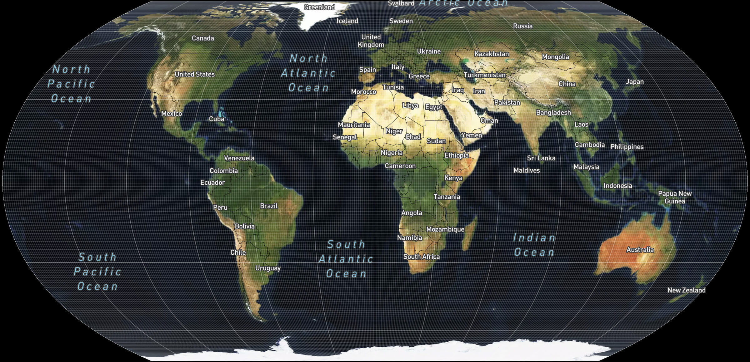
Reimagining projections for the interactive maps era
Reimagining projections for the interactive maps era
Maps
GL JS
Data Visualization
Maps
Cartography

Measuring the impact of school connectivity in the Giga Initiative: How we built it
Measuring the impact of school connectivity in the Giga Initiative: How we built it
Community
Isochrones
Non-Profit and NGO
Education
Public Health

Company
Adtech Tokyo 2021 Report
Adtech Tokyo 2021 Report
Company
No items found.

Climate visualizations for the people: Probable Futures
Climate visualizations for the people: Probable Futures
Community
Climate
Environment
Data
Data Visualization

Mapmakers take action on climate change
Mapmakers take action on climate change
Community
Environment
Climate
Data Visualization
Maps

Releases
Mapbox GL JS v2.6
Mapbox GL JS v2.6
Releases
3D
Data Visualization
GL JS
Maps

Releases
Realistic 3D experience with Terrain updates
Realistic 3D experience with Terrain updates
Releases
3D
Outdoor

Mapbox commitment to climate action
Mapbox commitment to climate action
Environment
Community
Climate

Maps
Why The Washington Post used MTS (Mapbox Tiling Service) to visualize census data
Why The Washington Post used MTS (Mapbox Tiling Service) to visualize census data
Maps
MTS
Maps
Census
Storytelling

Releases
Maps SDK v10
Maps SDK v10
Releases
Maps

Maps
Updated 50 cm imagery covering Israel and Palestine
Updated 50 cm imagery covering Israel and Palestine
Maps
Satellite Imagery
Imagery

Maps
Novas imagens aéreas para Portugal e França
Novas imagens aéreas para Portugal e França
Maps
Imagery
Satellite Imagery
There are no items matching the current filters.
Ready to get started?
Create an account or talk to one of our experts.