Using isochrones to understand reachability in web and mobile applications
When building location-based applications, one of the most common questions is: What can be reached within a given amount of time?
The answer isn't as simple as drawing a circle around a location. Roads, highways, traffic patterns, and transportation modes all influence how people move through the world. A destination that is only a few miles away may take significantly longer to reach than another location that is farther away.
This is where isochrones come in.
An isochrone represents the area that can be reached within a specified travel time or distance from a starting point. Generated using routing data and road networks, isochrones provide a more realistic understanding of accessibility than simple radius-based calculations.
The Mapbox Isochrone API makes it easy to generate these travel-time areas and use them in applications ranging from delivery planning and store locators to location intelligence and spatial analysis.
Why use isochrones?
In most places, distance does not equal travel time.
Two locations might both be five miles away, but one could take twice as long to reach because of road types, route availability, traffic patterns, terrain, or transportation mode.
Traditional radius-based searches assume:
- Travel is possible equally in all directions
- There are no obstacles
- Speed is consistent everywhere
Real-world travel doesn't work this way.
Isochrones provide a more accurate representation of reachability by modeling how people actually move through a transportation network.
This allows developers and businesses to answer questions such as:
- Which customers can be served within 30 minutes?
- Which stores are reachable within a 15-minute drive?
- Which restaurants should be shown as nearby?
- Which delivery requests fall within an operational service area?
In each case, travel time is often more meaningful than straight-line distance.
How the Mapbox Isochrone API works
The Mapbox Isochrone API calculates the area that can be reached within a specified travel time or distance from a starting location.
The API returns contours as polygons or lines that can be used in applications, analytics workflows, and map visualizations.
With the API, you can:
- Calculate isochrones up to 60 minutes
- Generate time-based or distance-based contours
- Use driving, cycling, or walking profiles
- Return polygons or line contours
- Create travel-time service areas
- Build location-aware workflows and applications
Behind the scenes, the API uses routing intelligence and road network data to model realistic travel behavior. The resulting polygons reflect actual reachability rather than simple geometric distance.
Isochrones aren't just for display
Many developers think of isochrones as something that is visualized on a map.
While displaying isochrones as a map layer is a common use case, some of the most powerful applications use them entirely behind the scenes.
The polygon generated by the Isochrone API can act as a spatial query area for filtering locations, evaluating coverage, or making operational decisions.
Examples include:
Point-of-interest filtering
A travel application may want to show restaurants that can be reached within a 10-minute drive instead of showing every restaurant within a five-mile radius.
Rather than displaying the isochrone itself, the application can use it to determine which locations should appear in search results.
Delivery coverage analysis
Delivery providers can use isochrones to determine whether an address falls within a service area.
Instead of maintaining static delivery boundaries, coverage can be calculated using realistic travel times.
Store and market analysis
Retailers can evaluate which neighborhoods can reach a store within a target travel time and compare accessibility between potential locations.
Service provider matching
Field service teams, technicians, and on-demand platforms can use isochrones to determine which providers can realistically reach a customer within a desired timeframe.
In all of these scenarios, users never need to see the isochrone. The API powers the logic behind the experience.
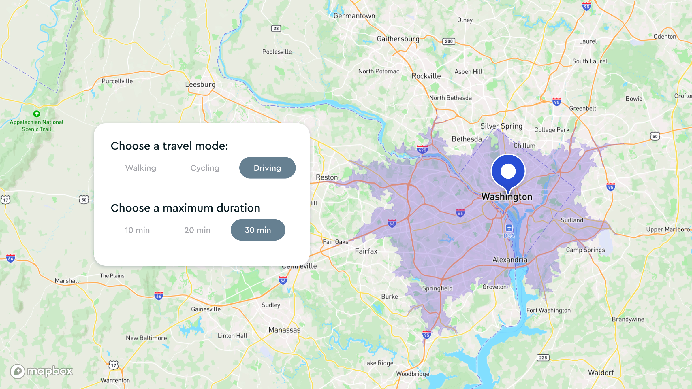
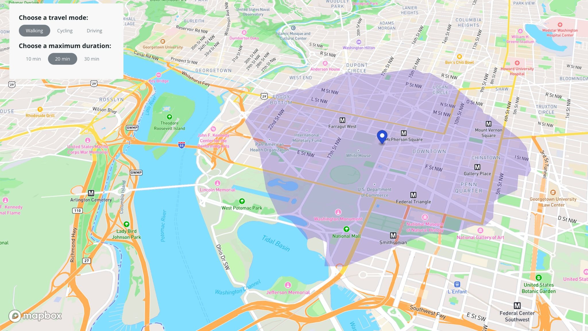
Try it yourself with the Isochrone API playground
One of the easiest ways to understand isochrones is to experiment with them.
The Mapbox Isochrone API playground lets you:
- Drag a marker to any location
- Adjust travel times
- Switch between driving, cycling, and walking profiles
- Generate contours instantly
By testing different locations and travel modes, you can quickly see how accessibility changes based on geography and transportation networks.
You can explore questions like:
- How far can a delivery driver reach in 20 minutes?
- Which neighborhoods are accessible within a 15-minute bike ride?
- How does reachability differ between urban and suburban areas?
The playground is a fast way to prototype ideas before integrating the API into production applications.
Build your own application
If you want to go further, the Mapbox tutorial walks through building a web application with the Isochrone API.
In the tutorial, you'll learn how to:
- Request isochrone data from the API
- Add isochrone layers to a map
- Allow users to select travel modes
- Configure travel-time ranges
- Build interactive accessibility experiences
The result is a working application that demonstrates how travel-time analysis can be integrated into real products.
What makes the Mapbox Isochrone API different
Travel time and distance in one API
Mapbox supports both time-based and distance-based contours, making it easy to model different accessibility scenarios.
For example:
- Within 15 minutes
- Within 10 miles
- Comparing travel-time reach versus distance-based reach
Multiple travel modes
The API supports:
- Driving
- Cycling
- Walking
Because each mode uses different routing assumptions, the resulting contours accurately reflect how different users move through the transportation network.
Flexible outputs
Developers can generate:
- Polygon contours for analysis and coverage calculations
- Line contours for custom visualizations
This flexibility allows the same API to support both operational workflows and user-facing experiences.
Built on routing intelligence
The API uses routing logic rather than simple geometry.
This means:
- Roads and paths are respected
- Route restrictions are considered
- Travel speeds vary appropriately
- Results reflect realistic movement patterns
Easy to test and integrate
The playground, documentation, and tutorials make it easy to move from experimentation to production.
Teams can rapidly test ideas, evaluate travel-time scenarios, and integrate isochrone analysis into existing applications.
How organizations use isochrones
From retail to delivery to real estate, organizations across many industries are finding ways to utilize isochrones in their maps:
Retail and store planning
Retailers can evaluate accessibility around stores, compare locations, and identify underserved areas based on travel time rather than straight-line distance.
Delivery and logistics
Delivery operations can define service areas, evaluate customer coverage, and optimize operational reach using realistic travel-time constraints.
Real estate and urban planning
Developers and planners can analyze accessibility to jobs, schools, healthcare facilities, and transportation infrastructure.
Travel and tourism
Travel applications can recommend destinations, attractions, and experiences that are realistically reachable within a user's available time.
On-demand services
Service marketplaces can match users with nearby providers based on travel-time availability rather than geographic proximity alone.
Kraken, a cloud-based, AI-powered operating platform, uses the Mapbox Isochrone API to dynamically stage jobs based on driving distances, visualizing these and all assigned routes on internal dashboards with Mapbox GL JS maps and within engineers’ Kraken app using the Mapbox Mobile Maps SDKs.
With Mapbox, we’re able to schedule and route engineers more effectively. This has allowed us to reduce wasted time on the road, increase service capacity, and lower costs and emissions. -Guy Walker, VP of Product, Kraken
Why isochrones matter
The Mapbox Isochrone API helps developers answer a fundamental location question: what can be reached within a given travel time or distance?
Whether you're visualizing accessibility on a map, calculating delivery coverage, filtering nearby locations, evaluating service areas, or building location-aware applications, isochrones provide a practical way to model real-world reachability.
With support for multiple travel modes, time- and distance-based contours, and easy integration into web and mobile applications, the Mapbox Isochrone API makes it simple to bring travel-time analysis into your products.
Get started with Mapbox today.
FAQs
What is the difference between an isochrone and a radius-based search?
A radius-based search uses straight-line distance from a point. An isochrone uses travel time or network distance based on roads, routes, and transportation networks. As a result, isochrones provide a more realistic representation of accessibility.
How accurate are isochrones?
Accuracy depends on the quality of the underlying routing data and travel assumptions. The Mapbox Isochrone API uses routing intelligence and road network data to generate realistic travel-time contours.
Can I use isochrones for walking and cycling?
Yes. The Mapbox Isochrone API supports driving, cycling, and walking profiles.
What is the maximum travel time supported?
The Mapbox Isochrone API supports contours up to 60 minutes and allows multiple contours within a single request.
Do I need coding experience to use the Isochrone API?
You can begin exploring isochrones using the playground without writing code. Developers can then integrate the API into applications using the documentation and tutorials.


Related articles

令和に生まれた自動車メーカーが完全自動運転EVの量産を目指して| 導入事例 - Turing株式会社
Never miss a turn again with Mapbox 3D Lanes
%20(1).png)