Back to all cases

Mapbox powers Athenium's geospatial intelligence, helping achieve 99% customer retention through fast, interactive visualizations.

Key benefits of building with Mapbox
- Developer-friendly and forward-thinking mapping tools and APIs help Athenium accelerate time to market with sophisticated, AI-driven geospatial applications.
- Mapbox custom data tiling and rendering deliver high-performance, scalable weather visualizations of massive, dynamic datasets.
- Mapbox has helped drive 99% customer retention, with Athenium customers consistently citing the speed, clarity, and responsiveness of maps as a key driver of satisfaction.
products used
About Athenium
When hailstorms, hurricanes, tornadoes, or flooding strike, insurance carriers need to quickly understand which properties were affected, assess exposure, and begin claims processing. Raw weather data alone is not enough. It has to be transformed into intuitive geographic intelligence that underwriters, claims adjusters, and risk analysts can immediately understand.
Athenium is a leading provider of risk and quality management solutions, offering advanced analytics software to optimize performance and manage risk in the insurance sector. The natural hazard intelligence company combines weather science with geospatial technology to help insurers visualize risk, monitor severe weather, and analyze post-event impacts using interactive maps.
Athenium sits at the intersection of two things that are deeply spatial: the weather, which moves across the earth, and risk, which varies by the inch. Every product we build only makes sense on a map.
Jonathan Fairman, General Manager, Risk Intelligence at Athenium
Weather intelligence that is actually easy to use
Athenium's mission is simple: build the highest-quality natural hazard intelligence possible and make it easy for customers to access.
Its SaaS platform delivers proprietary weather and risk data through dashboards, APIs, cloud-hosted datasets, and increasingly, AI-powered experiences. Insurance customers rely on Athenium to evaluate natural hazard risk before events occur and verify weather impacts afterward for insurance claims. While insurance remains the primary commercial market, Athenium also provides similar intelligence into the federal and other commercial sectors.

Presenting detailed weather and risk intelligence requires a mapping platform capable of handling enormous amounts of dynamic geospatial data.
We had a build vs. buy decision, and it undoubtedly made more sense to buy. Mapbox provides all of the capabilities we need to create stunning visualizations.
Brian Reilly, Sr. Manager, Engineering, Athenium
Rendering high-resolution weather intelligence at scale
Athenium uses Mapbox GL JS to power interactive maps across products including: Gauge, its natural hazard scoring platform; Dexter, for post-event weather verification; and Beacon, for storm tracking and alerting.
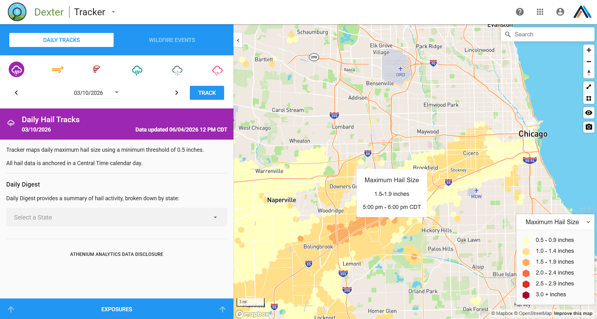
Mapbox GL JS is easy to use and expressive. Whenever we run into a challenge, the documentation has what we need to address it. The HTTP APIs are incredibly reliable and well documented too. We evaluated several other JS web mapping libraries, and none matched the expressiveness or ease of use that Mapbox GL JS gives our team.
Brian Reilly, Sr. Manager, Engineering, Athenium
Behind the scenes, Athenium uses Mapbox Tiling Service (MTS) to process proprietary weather intelligence into datasets before publishing them. Using Mapbox tiles allows clients to smoothly visualize data on severe weather events—including hail, tornadoes, wind, rainfall, snowfall, and freezing rain—across the continental United States.
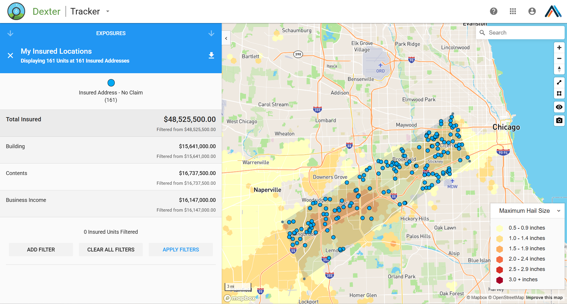
MTS is central to delivering weather data fast enough to be actionable. Static tile providers couldn't support the dynamic experience our clients need, from smoothly rendering 1 km U.S. weather contours to instantly zooming, toggling perils, and comparing historical events. When severe weather hits, clients need answers immediately, and the Mapbox vector and raster tile architecture makes that possible.
Mojtaba Dyanati, Vice President, Data Science & Engineering, Athenium
Faster decisions when every minute counts
For insurance customers, speed directly impacts business outcomes. Following severe weather events, claims teams use Athenium's platform to identify affected properties and begin exposure analysis almost immediately.

With Mapbox powering visualization performance, customers can complete exposure reviews within 90 minutes of an event. The mapping experience has also become a competitive differentiator for Athenium.
Leading the way on AI and weather intelligence
Today, Athenium is leading the way in redefining geospatial workflows with AI, turning plain-language questions into instant, location-based insights. Its Weather MCP enables users to ask questions such as, “Show me an interactive map of hail in the US for April 15, 2026.”
The response includes a Mapbox-rendered visualization embedded directly inside the AI workflow, allowing users to move from question to geographic understanding in seconds.

Looking ahead, Athenium believes AI agents and MCP servers will dramatically expand access to complex geospatial analysis, and is already exploring pairing Mapbox Model Context Protocol (MCP) capabilities with its own specialized geospatial tooling to combine geocoding, reverse geocoding, and place search into streamlined developer workflows.
What's kept us loyal isn't just the technology, it's that Mapbox keeps growing in the same direction we're heading. Today, our Weather MCP generates live, interactive Mapbox-rendered maps on demand, embedded directly inside AI agent responses.
Mojtaba Dyanati, Vice President, Data Science & Engineering, Athenium
Ten years with Mapbox, 99% customer retention
Over the past decade, Mapbox maps have enabled Athenium to deliver its core objectives to their customers, driving a remarkably high annual customer retention rate of 99%.
Our customers consistently cite the speed, clarity, and responsiveness of Athenium's geospatial visualizations during product evaluations. When we identify a new market opportunity, Mapbox contributes to unmatched speed to market, helping us spin up industry-leading location-based products driven by high-quality data visualizations. The decision to choose Mapbox has aged extraordinarily well. More than a decade later, we're still building on Mapbox — and we've never looked back.
Jonathan Fairman, General Manager, Risk Intelligence at Athenium