What is location intelligence?
.png)
Location intelligence is often described in simple terms: using data about places to make better decisions. That’s true, but it’s also too narrow.
At its core, location intelligence is about understanding how the world works through location. It connects geospatial data, business data, movement, and context, so teams can make informed choices about operations, strategy, and customer experience.
In many definitions, location intelligence sits under business intelligence. It adds a layer to traditional data analysis — helping answer questions like:
- Where should we open our next store?
- How do people move through this area?
- Which locations perform better, and why?
That foundation is important, but it only scratches the surface.
Today, location intelligence is evolving into something broader. It is no longer just a reporting tool or a niche category. It is becoming a flexible platform that helps teams explore, visualize, and act on data tied to the physical world — often powered by modern mapping platforms like Mapbox that combine maps, search, navigation, and data into a platform.

Why the traditional definition falls short
For many people, “location intelligence” brings up a few common ideas:
- Targeted advertising based on location
- Military or surveillance use cases
- Static maps or dashboards
These interpretations are understandable, but they limit how the concept is used.
It’s not just location-based targeting
Location intelligence is often confused with ad targeting. That is one application, but it is not the focus here.
The broader goal is decision-making — understanding patterns and opportunity across geographic areas.
It’s not limited to situational awareness
Instead of just monitoring what is happening, companies use location intelligence to:
- Plan operations
- Allocate resources
- Design better products
It’s not just a static map
Maps are a starting point, not the end goal.
Modern platforms show this shift clearly. Instead of static visuals, maps are now dynamic interfaces where teams can layer data, run analysis, and interact with real-world systems in real time.
A broader view: location intelligence as a living system
A more useful way to think about location intelligence is as a living system.
It is not a single dataset or tool. It is an environment where:
- Data from different sources comes together
- Location provides shared geographic context
- Insights evolve as conditions change
This is how platforms like Mapbox approach location.
Rather than offering a fixed map, Mapbox provides a platform for building location-driven experiences. Teams can combine their own datasets with global map data, then customize how that data is visualized and used across applications.
This includes working with:
- Global basemaps and 3D environments
- Custom datasets (sales, operations, mobility)
- Movement and traffic data
- Boundaries and geographic layers
This flexibility matters because no two businesses use location the same way.
How location intelligence connects to business intelligence
Location intelligence is often described as a subset of business intelligence.
Business intelligence asks:
- What happened?
- Why did it happen?
Location intelligence adds:
- Where did it happen?
- How does geography influence the outcome?
That “where” unlocks new insights.
For example:
- Sales vary by neighborhood, not just region
- Delivery times depend on traffic, not just distance
- Store success depends on accessibility and foot traffic
By adding spatial context, teams uncover patterns that traditional dashboards miss.
How location intelligence works
Most location intelligence workflows follow a common pattern:
- Data collection: Gather geospatial data, business data, and external datasets
- Data integration: Combine datasets using geographic references
- Spatial analysis: Analyze patterns such as proximity, clustering, or trade areas
- Visualization: Map and explore insights
- Decision-making: Apply insights to real-world operations
Platforms like Mapbox support this through APIs and SDKs for maps, geocoding, routing, and spatial visualization, allowing teams to move from raw data to application quickly.
Real-world examples of location intelligence
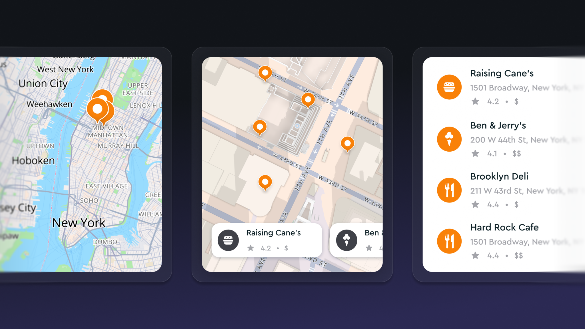
Retail: choosing the optimal store location
Retailers use location intelligence for site selection and trade area analysis.
They combine:
- Foot traffic data
- Competitor locations
- Demographic trends
- Accessibility
With platforms like Mapbox, these insights can be visualized in custom store locator experiences or internal planning tools, helping teams evaluate opportunities faster.
Logistics: improving delivery performance
Logistics companies use location intelligence to:
- Optimize routes
- Predict delivery times
- Adjust for traffic
Mapbox navigation enables teams to calculate travel times and dynamically adjust routes based on real-world conditions.
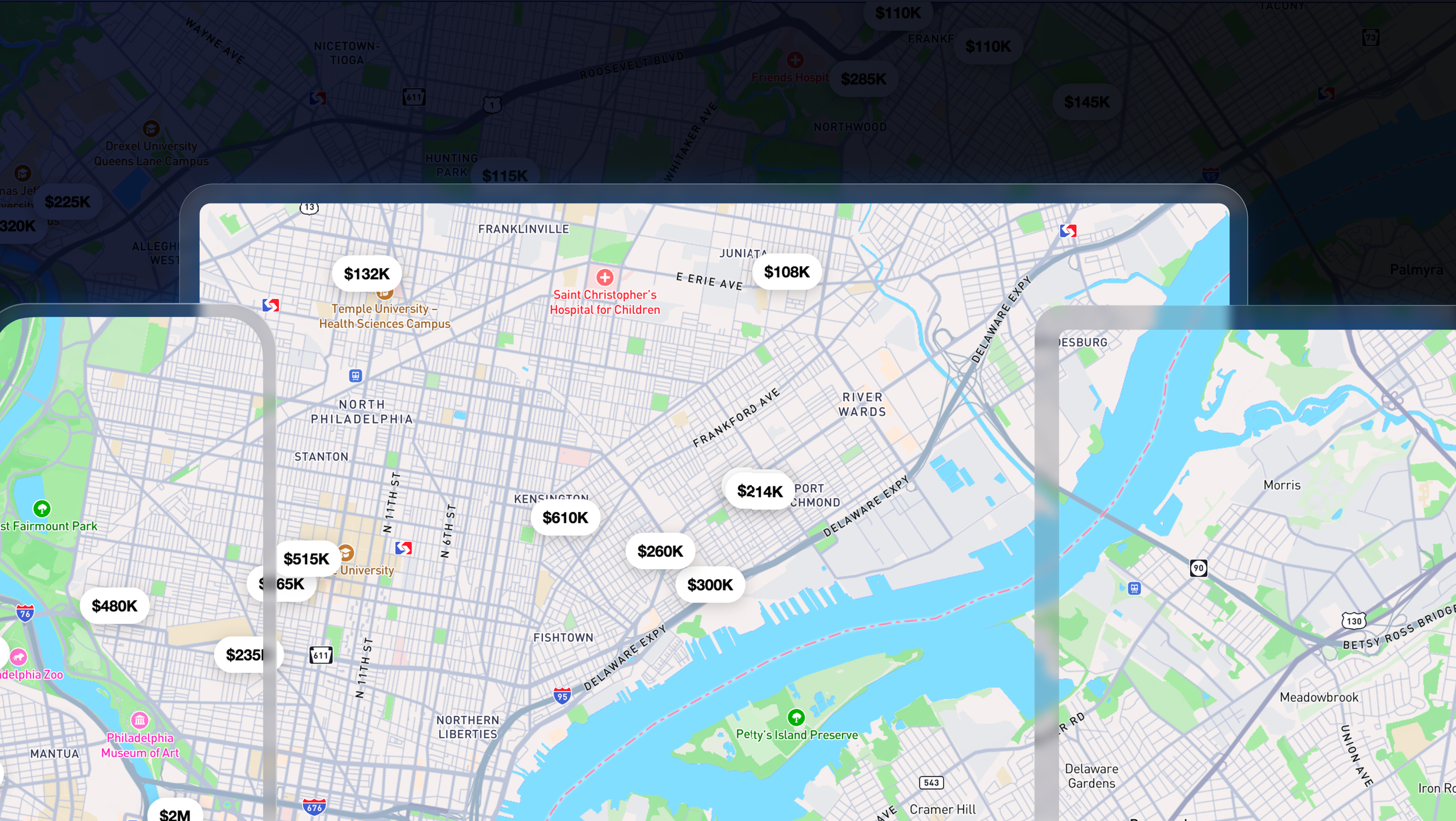
Real estate: evaluating market potential
Real estate teams analyze:
- Nearby amenities
- Transportation access
- Population growth
Interactive map visualizations make it easier to compare locations and communicate investment decisions.
Mobility and automotive: shaping in-car experiences
In mobility, location intelligence powers navigation, search, and in-car experiences.
Mapbox supports these use cases with the Navigation SDK and high-fidelity map rendering, enabling everything from mobile navigation apps to in-vehicle systems.
Business operations: understanding performance by place
Companies use location analytics to:
- Compare regions
- Identify underperformance
- Adjust strategy
This turns location into a measurable driver of performance.
Location intelligence vs GIS
Location intelligence and GIS are closely related:
- GIS (Geographic Information Systems) focuses on collecting and analyzing geospatial data.
- Location intelligence focuses on applying those insights to business decisions.
Location intelligence in the age of AI
AI can identify patterns, but it still needs context to make those patterns useful.
Location provides that context.
It helps:
- Anchor data to real-world places
- Connect datasets through geography
- Make insights easier to interpret and act on
This is where location intelligence becomes essential. Many AI systems struggle with spatial reasoning — understanding proximity, direction, movement, or how places relate to one another. Without that, even strong models can fall short on real-world tasks.
Location AI addresses this gap.
Location AI enables artificial intelligence to understand geospatial data, location context, and how information connects across the physical world. Instead of treating location as just another data point, it makes geography a core part of how AI systems reason and respond.
The Mapbox approach to Location AI reflects this shift.
Rather than adding maps as a visualization layer after the fact, Mapbox provides a unified geospatial platform that AI systems can directly interact with. Through APIs and the Model Context Protocol (MCP) Server, developers can give AI agents access to:
- Geocoding and location search
- Routing and travel time calculations
- Global map data and metadata
- Spatial queries across millions of locations
This allows AI systems to not just analyze data, but to understand where things happen and why it matters.
It also changes how applications are built.
Developers can connect large language models and AI agents directly to location services, or use tools like the Mapbox MCP Server and DevKit to embed geospatial capabilities into coding workflows. This reduces the complexity of integrating maps, data, and AI — and makes it easier to build location-aware applications from the start.
At the experience level, this opens up new possibilities.
Maps are no longer just interfaces for viewing information. They can become interactive, conversational surfaces, where users ask questions, explore places, and get context-aware answers. Examples include:
- Conversational map interfaces powered by AI agents
- Voice-based assistants that guide drivers with location-aware context
- Feedback systems that analyze and categorize map-related input automatically
In this sense, location intelligence becomes a foundation for how AI systems interact with the real world — turning geographic context into something AI can reason about, communicate, and act on.
Building with location intelligence
One of the biggest shifts is accessibility.
You can bring your own data
Combine internal data with geospatial datasets to create richer insights.
You can visualize and explore
Maps act as a shared interface for analysis and communication. Mapbox enables fully customizable maps, allowing teams to design experiences that match their product or brand.
You can build custom solutions
Teams can build:
- Internal dashboards
- Customer-facing apps
- Operational tools
This is possible because the Mapbox platform provides a full stack — maps, data, APIs, and SDKs — rather than a single tool.
The future of location intelligence
Location intelligence is becoming a core layer of modern software.
It supports:
- Data-driven decisions
- Better customer experiences
- More efficient operations
Platforms like Mapbox reflect this evolution — moving beyond maps to provide a foundation for location-aware applications, AI systems, and real-world decision-making.
As the world evolves, one thing remains constant: Understanding “where” leads to better decisions about “what to do next.”
Frequently asked questions
What is location intelligence in simple terms?
Using data about places to make better decisions.
How is location intelligence different from GIS?
GIS analyzes spatial data. Location intelligence applies it to business decisions.
Is GIS under threat from AI?
No. AI is expanding what GIS and location intelligence can do. For example, the Mapbox Location AI capabilities help systems understand geospatial context, making AI outputs more actionable and grounded in the real world. GIS remains foundational — AI simply makes it more powerful.
What data is used?
Geospatial, demographic, foot traffic, and business data.
Can I use my own data?
Yes. Modern platforms allow full data integration.
How does location intelligence support AI?
Location adds real-world context, making AI insights actionable.


Related articles
Build once, run everywhere: Web support comes to the Mapbox Maps SDK for Flutter

From airports to stadiums, maps are elevating the soccer fan experience
