Back to all cases

UNHCR visualizes global operations with custom Mapbox basemaps, built with GL JS and the Mapbox Tiling Service

Key benefits of building with Mapbox
- Mapbox GL JS provides a flexible platform for a wide range of maps
- The Mapbox Tiling Service powers fast and efficient processing of global datasets
- Mapbox Studio enables high-precision customization of map layers
products used
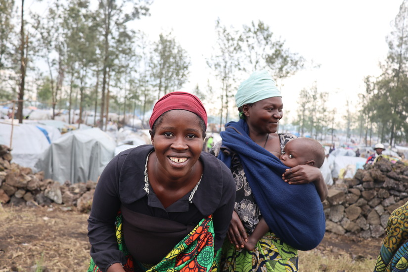
About the UN Refugee Agency
UNHCR, the UN Refugee Agency, is a global organization that safeguards the rights and well-being of refugees, forcibly displaced communities, and stateless individuals.
Since its inception, UNHCR has spent over half a century assisting millions of refugees by protecting their rights and facilitating the construction of a better future for those forced to flee their homes due to conflict and persecution.
Coordinating operations in over 125 countries, UNHCR provides essential life-saving assistance, including shelter, food, water, and medical care to people who often have no one else to turn to. UNHCR collaborates with countries to improve and monitor refugee and asylum laws and policies, ensuring the protection of human rights.
Dynamic location data for the displaced
Location-based data is a key component when it comes to visualizing and telling the stories of refugees and other forcibly displaced people. UNHCR uses the geographic data they collect— including information about where refugees are, where they came from, the availability of relevant services, and the locations of offices, warehouses, and camps—to coordinate operations and create compelling advocacy campaigns.
Data scientists and data managers at UNHCR realized that they needed to pair their dynamic data with a robust platform for creating interactive maps, flexible enough to handle diverse geographic data and a wide range of applications. Static maps, such as PDFs, are insufficient in rapidly changing situations and when stakeholders expect to interact with geographic data on screens or mobile devices. Without a modern digital mapping solution, UNHCR risked having its partners, governments, donors, and media find data elsewhere, leading to a fragmented and potentially misleading information landscape.
At the same time, UNHCR needed a mapping solution that would allow their maps to follow the UN-mandated standards for representing national borders and place names.
Most importantly, UNHCR required a solution that could be smoothly integrated into custom dashboards, enabling users to access data without license or account requirements, ensuring that their map-based data and reports would remain intuitive and available to a broad audience.
A flexible Mapbox toolkit for a diverse agency
Mapbox provides the combination of customizability, performance capabilities, and precise location-based data that UNHCR requires.
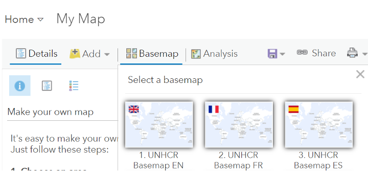
Using Mapbox GL JS for interactive web maps in The Operational Data Portal (ODP), UNHCR has built a stable, easy-to-use, and interactive map experience. Mapbox Studio allows the UN to seamlessly create new map styles and rapidly adjust designs to meet the specific requirements of the United Nations. The ability to customize basemaps, including tweaking integrated layers at different zoom levels, has significantly enhanced user experience on the ODP.
Mapbox is a flexible platform. The Mapbox Tiling Service (MTS) enables UNHCR to upload and process their official boundary data to replace the default boundaries in Mapbox, allowing the agency to follow the UN-mandated standards for representing national borders and names. UNHCR can then use their custom styles across various platforms and software used within the agency and by external partners, from Mapbox GL JS, to ESRI, to Power BI dashboards.
The tools and support generously provided by Mapbox enable UNHCR and its partners to better serve those that need assistance the most. Using Mapbox, UNHCR is able to produce maps that meet UN standards while also providing the best performance and reliability for our inter-agency coordination and data sharing platform.
Pierre Vernier, Information Management Officer, UNHCR
On-demand data storytelling
Working with the Mapbox toolkit has inspired UNHCR to release new storytelling formats on the UNHCR Data visualization platform. The data story ‘Returns to Afghanistan’ combines an interactive GL JS-based Mapbox Interactive Storytelling map with static maps and other images and charts. For the story ‘Sudan: One year of spiralling conflict and displacement’ an animated Mapbox GL JS globe provides an eye-catching and interactive visual, enhancing user engagement. Since choosing Mapbox as a major platform for data storytelling maps, UNHCR has seen notable user experience and engagement increase. At the same time, operational resources and implementation periods have decreased.
.gif)
The Mapbox Interactive Storytelling template provides a flexible, low-code foundation for building map-based stories with just a few steps. Broad customization options allow UNHCR to tailor their storytelling maps to meet the style and cartographic requirements for all UN maps, including disputed boundaries around the world, for which the UN has specific symbology.
.gif)
The ability to quickly create maps in various languages is significant for an organization operating around the world and for global audiences. Building with Mapbox, UNHCR creates base map versions in French and Spanish. On top of a base map, UNHCR overlays operational data using the rich set of Mapbox customization features. As a result, UNHCR presents complex data in a visually appealing and understandable way.
Many UNHCR storytelling projects reflect current events, making a quick turnaround time for production essential. The ease of building with Mapbox provides UNHCR with full operational autonomy and allows the production of new projects on tight deadlines, such as the map-based data story of the crisis in Sudan, implemented in just 5 days.
Mapbox implementation streamlined operations, reduced loading time, and enhanced interactivity of our maps. Resulting in greater user experience for our audience.
Lei Chen, Information Management Officer, UNHCR
Equipping emergency relief operations with location technologies
The Operational Data Portal (ODP), powered by Mapbox, is one of the main UNHCR tools for data visualization and sharing. It is the central platform for coordination of refugee response efforts across UN agencies and partners with nearly 4 million pageviews. By providing geospatial data and critical information on forcibly displaced populations, the ODP paves the way for a coordinated and timely response.
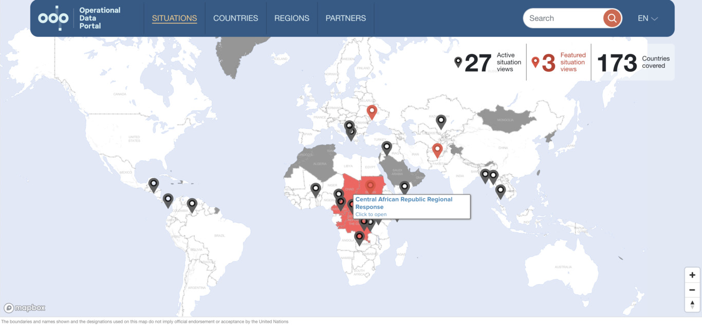
As time and immediate actions are essential for emergency relief operations, UNHCR must respond to crisis situations around the globe quickly. Therefore fast and seamless implementation is crucial for the Agency. UNHCR can adapt their existing Mapbox maps in short time and efficiently include them in new country and situation pages as new refugee emergencies arise. Thanks to the efficient mapping platform they have built with Mapbox, the UNHCR has improved the performance of their web portals and pages, enhanced user experience, and achieved greater impact in sharing geographic information with their global audience.
Mapbox allows UNHCR to create recognizable yet customized maps for use in our information products. These products are an important way for UNHCR to advocate on behalf of forcibly displaced and stateless people.
Mariann Urban,Information Management Officer,UNHCR


