Back to all cases
Transforming how real estate and land professionals create and use interactive maps, built on the Mapbox platform.

Key benefits of building with Mapbox
- Seamless cross-platform support for web and mobile.
- High-power tileset hosting and rendering supports extensive custom data overlays.
- Flexible customization options makes the Land id™ map style instantly recognizable.
products used
About Land id
Land id™ is a web and mobile map making application that caters to real estate professionals, brokers, property appraisers, and land investors. The company enables anyone to create beautiful, data-rich interactive maps designed to tell compelling property stories. While many mapping software solutions require significant training, Land id™ makes mapping accessible to everyone, regardless of their technical expertise. Land id™ equips everyone with intuitive tools to assess property value, understand land features, and market properties effectively.
Equipping real estate professionals with maps to be proud of
Creating high-quality, professional maps in the real estate industry has often been a time-consuming, overly technical process. Traditional Geographic Information Systems (GIS) software are generally not user-friendly for professionals who do not have GIS training, and simpler solutions like annotated screenshots of maps fail to produce polished maps that impress clients. Land professionals are often stuck trying to use static, multipage PDFs of maps showing various different considerations in a fragmented and overwhelming narrative.
It was always fascinating that for an industry whose little cliché term is ‘location location location,’ maps seem to always be an afterthought when it came to how real estate approaches marketing or understanding properties.
Steve Roberson, Founder, Land id
What the founding team recognized in 2014 is that interactive maps, on web and mobile, were the way of the future. Consolidating parcel information into a single, dynamic map that could be viewed in the office, in the field, or sent virtually to clients would transform the practicality of using mapping software in the land business. Land id™ set out to create an interactive, cloud-based mapping application that combines ease of use with professional-grade results, tailored specifically to the unique needs of real estate and land professionals.
Mapbox provides the ‘Eureka!’ moment
From its beginning in 2014, the Land id™ team (initially named Mapright), chose Mapbox as the foundation for their application. The Mapbox Mobile Maps SDKs, Mapbox GL JS library, and high-quality Mapbox basemaps provided the team with a flexible, reliable platform upon which to build and grow. Mapbox even provided initial inspiration for how to approach the problem: the Mapbox Studio option to share an interactive preview of a custom map style via a simple URL.
As a GIS specialist, I've used pretty much every geospatial application under the sun. The light bulb moment for me was when I saw the ‘share map’ experience through Mapbox. I'd never seen anything like that before and thought that was revolutionary. I’ve always seen Mapbox as being the very cutting edge of interactive maps, and that's where we want to be with Land id.
Steve Roberson, Founder, Land id
Designing customized maps overlays for an instantly recognizable brand
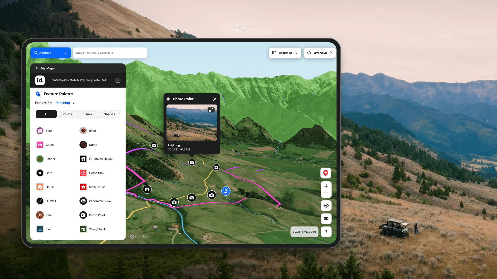
Another big consideration for Land id™ was the ability to control the presentation and the aesthetic values of map overlays. The company knew that real estate and land professionals had numerous details that they would need to visualize on their maps, from surface water, to topography, to land use classifications, to custom property details. Today, even with over 40 different data overlays available, the Land id™ team can use Mapbox Studio and Mapbox tileset hosting to design each layer efficiently and thoughtfully to ensure a polished, and recognizable, map experience.
All of our custom data overlay layers are part of our branding. When someone makes a map with us, we want it to immediately resonate that it's a Land id™ map. So the control that Mapbox gives us over how we design the overlays was a huge deal – both in terms of how we tile the datasets for performance and in terms of full artistic styling control.
Steve Roberson, Founder, Land id
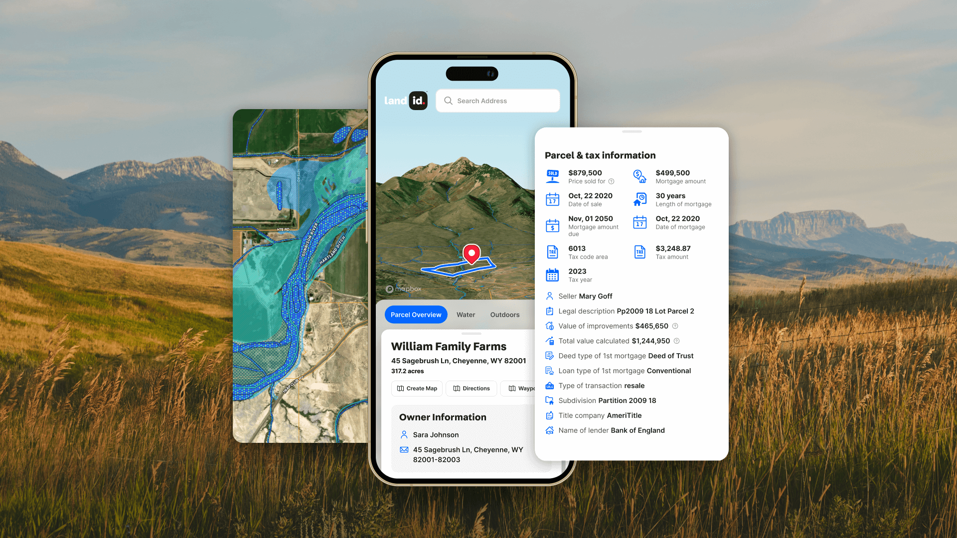
Discover, create, and showcase property maps anywhere
Land id™ supports users with three different modes: Discover, Create, and Showcase. In Discover, users can search, browse, and favorite properties to support their research. Users can find properties by address, parcel ID, or owner's name, instantly gaining access to boundary lines, tax data, and other key property information. In Create, users can create their own custom maps, adding layers and custom annotations. With advanced overlays, users can display critical data such as FEMA flood zones, water features, infrastructure, or even soil types. And in Showcase, users can share their maps with an audience, either with a live interactive map or images for a report. The features available in each mode are a clear demonstration of the Land id™ team’s deep and practical knowledge of the real estate and land management sectors.
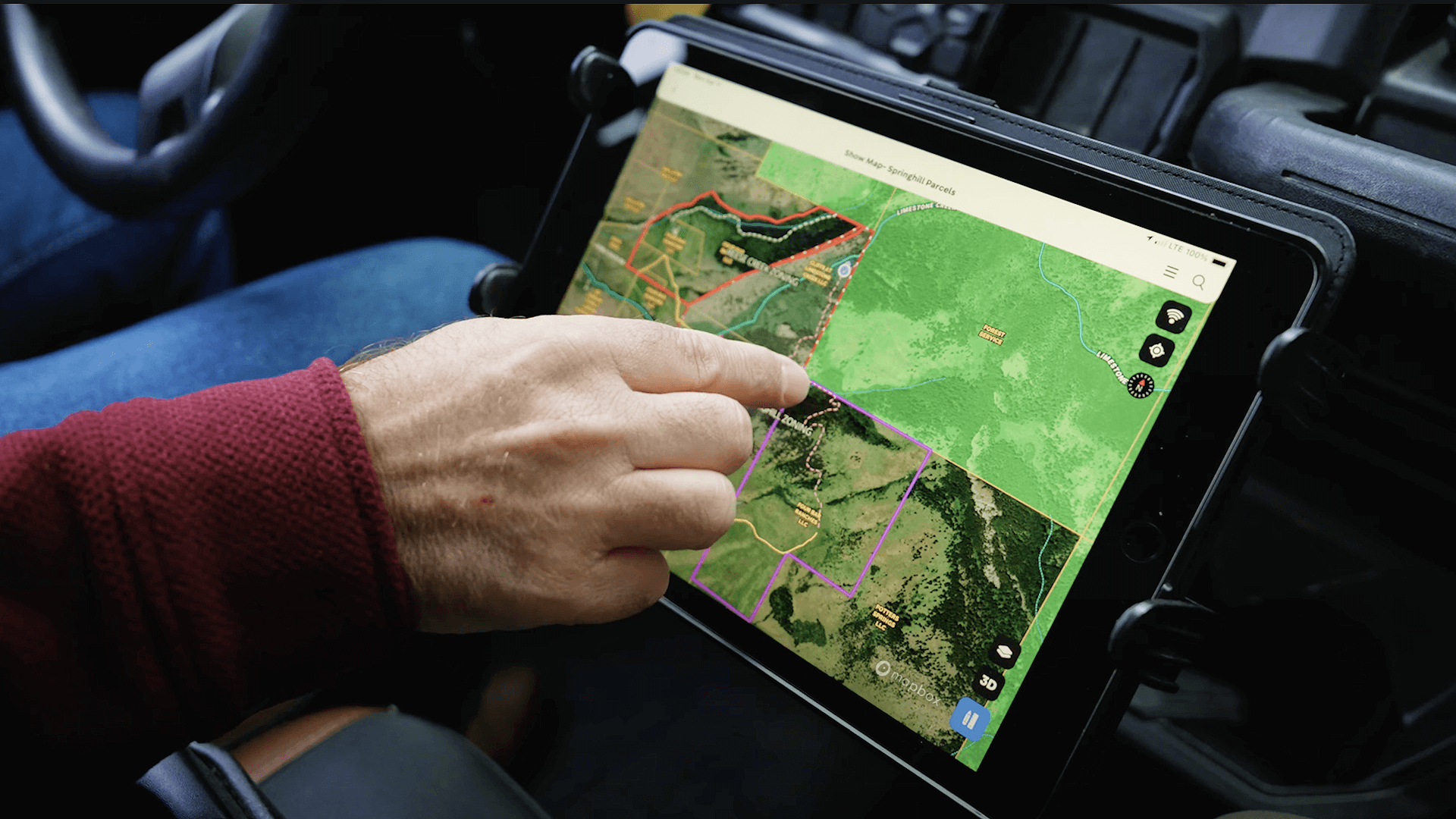
The cross-platform nature of Mapbox allows Land id™ to seamlessly sync across web and mobile applications, ensuring users can stay productive regardless of location. While at a desktop, agents can use the web interface to create detailed location maps with a minimal learning curve and no technical expertise required. Then, when in the field, agents can view and annotate maps on their smartphones without missing a beat.
What's really cool is all the layers and annotations we can add to our maps also render on the mobile app. So when you go out to a property you can see your live location, walking in real time on your survey or site plan or flood zone data.
Steve Roberson, Founder, Land id
Mapbox supports flexible real estate needs, from rural to urban to commercial
Land id™ has proved particularly effective for brokers and land managers in rural and ranch real estate, where property-specific features like houses, streams, and fence lines are market-critical. The platform also supports land investors performing remote analyses, demonstrating property appeal without the need for on-site visits.
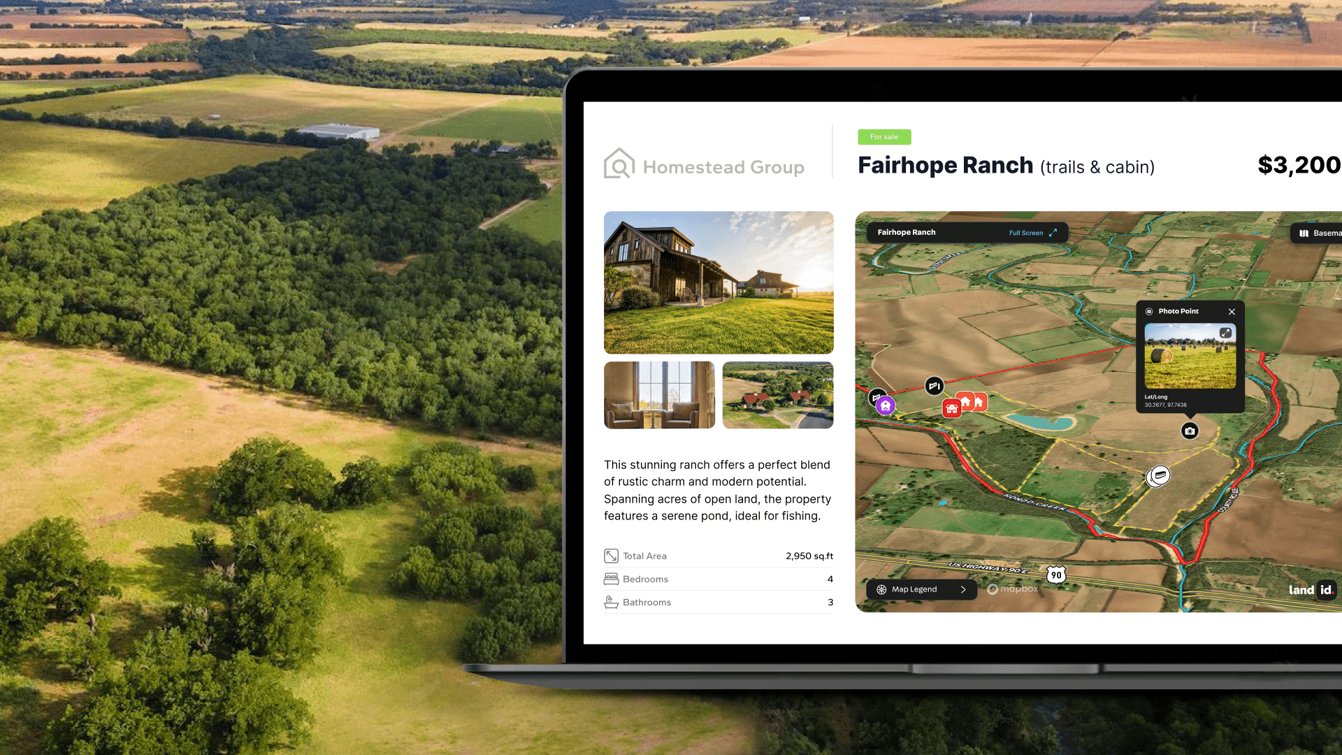
Built on the global Mapbox basemap, Land id™ can span rural properties and suburban or urban environments with ease. When applied to residential and commercial real estate, Land id™ excels at telling the story of a property’s context, using amenities, points of interest, surveys, site plans, and other contextual layers to highlight not only the property itself but also the surrounding area’s infrastructure and factors influencing a property’s valuation.
An agent told us about a one acre, multi-million dollar property for sale in Big Sky Montana that had been sitting on the market for two years. He used the Land id™ app’s tracking tool to trace out exactly where one could ski in and ski out to the property. Within two months, the property was sold. That agent would tell you without a doubt that the customized map that he was able to create was a major factor in conveying the unique appeal of the property.
Steve Roberson, Founder, Land id
Building with Mapbox accelerates success for Land id™
The technology from Mapbox has been instrumental in accelerating success for Land id™ as it reshapes the way the real estate industry uses maps – and map making. The tools delivered are user-friendly, loaded with advanced features, and have equipped land professionals with polished and practical maps for selling and managing properties. The customers of Land id™ appreciate the intuitive and visually appealing maps, reliable performance both in the office and in the field, and the ease with which they can create custom maps without needing to learn complex software.
Building on Mapbox from Day 1 has been central to our success. Knowing that we can depend on Mapbox for our underlying architecture – from high performance maps, to tileset hosting, to geocoding, to directions – that lets us focus on building features to serve the industries where we specialize.
Steve Roberson, Founder, Land id

.jpg)
